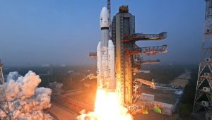


India successfully launched the NASA-ISRO Synthetic Aperture Radar (NISAR) satellite, taking a significant step towards international space collaboration. The $1.5 billion satellite is designed to monitor climate change and natural disasters with enhanced radar imaging capability. The Indian Space Research Organisation (ISRO) and the U.S. National Aeronautics and Space Administration (NASA) collaborated on this satellite mission for the first time.
A medium-lift rocket was launched from Satish Dhawan Space Centre at 12:10 GMT. NISAR is the world’s first Earth observation satellite to use two radar frequencies: L-band from NASA and S-band from ISRO. This dual-frequency capacity allows the satellite to detect changes in the Earth’s surface as small as a centimetre.
NISAR is now in a near-polar Sun-synchronous orbit about 747 km above Earth, and it will provide updated global surface data every 12 days. The data will be critical for following glacier melt, monitoring seismic activity, and observing shifts in vegetation and wetlands.
The satellite is projected to function for at least five years. NISAR data will be publicly available worldwide, reinforcing global efforts in climate science and disaster management.